
Land Surveying
W&A Engineering offers complete land surveying services in Alabama, Georgia, Tennessee, and North Carolina. Incorporating land surveying as an in-house discipline assures our clients that all the information gathered by our land surveyors from the site will be transferred and clarified to our engineers. In addition to using state-of-the-art equipment, we employ well-trained land surveyor crews who are professional and courteous, with experience in all facets of surveying.
- ALTA/NSPS Title Survey
- Boundary Survey
- Topographic Survey
- As-Built Survey
- Construction Staking
- Residential Services

ALTA/NSPS Title Survey
An ALTA survey is a complete land survey that provides detail on boundaries, site improvements, easements, rights-of-way, and other items affecting the ownership of land. An ALTA Survey is common with commercial properties to ensure the title to the land and improvements to the high degree that a commercial development may require. “Table A” from the “Minimum Standard Detail Requirements for ALTA/NSPS Land Title Surveys” helps to define a clear scope of what is shown on the survey.

Boundary Survey
The purpose of a boundary survey is to establish and/or retrace the boundaries of a property based on physical and documented evidence and includes locating or establishing monuments, such as an iron pin, at the corners of the property. Evidence such as fences, streams, marked trees, and utility easements, may also be located as evidence of ownership when conducting the survey.

Topographic Survey
Topographic surveys provide detail on the vertical relief of a property. The deliverable of a topographic survey will include spot elevations and contour lines to depict the relief of the surveyed area. A control network, either of an established vertical datum or of an assumed elevation, is established and relative elevations are measured throughout the site. A topographic survey also includes the physical features on the site such as streams, buildings, roads, and utilities.

As-Built Survey
As-built, or post-construction, surveys are often required by a city or county prior to issuing a certificate of occupancy. The completion of this survey ensures that the site was developed per the approved design and that drainage and utilities will perform properly. Lenders may also require a post-construction survey to confirm that buildings conform with zoning standards (buildings inside building setback lines, at or below maximum height) or to make sure that no walls or access drives have encroachments that could obstruct title.
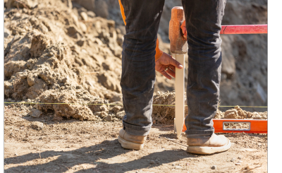
Construction Staking
Construction staking is required to bring the design plans to the field and to ensure that horizontal and vertical accuracy is maintained. Control and reference points are established on-site, followed by limits of construction and clearing. Contractors will then follow flagging and stakes set by the surveyor to mass grade and install storm and sanitary sewer structures and pipes. Buildings are laid out with high accuracy to ensure that walls and interior detail can be constructed per the architectural plan.
The final grading is completed with curb and gutter staking that ensures the site will drain properly. Providing clear and good quality construction staking services ensures that the project follows the design and that contractors have all the information they need to accurately construct the project.
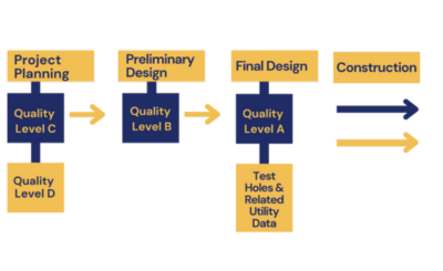
Subsurface Utility Engineering
Subsurface utility engineering services add value, quality, and accountability to any project. W&A Engineering is able to offer subsurface utility engineering at all quality levels including D, C, B, and A.
Level A: the most in-depth level of investigation, level A utilizes physical digging to locate exact spots of utilities using non-destructive methods such as vacuum excavation
Level B: identifies and locates underground utilities through non-invasive methods such as light electrical currents
Level C: uses on-site surveys and clues such as hand valves and sewer cover to plot utility locations
Level D: the most superficial level of investigation, Level D utilizes topographical surveys, plans from prior surveys, maps, and more to establish a loose utility map

Residential Services
We offer the land surveying services needed by residential property owners. If a property has not been surveyed in several years, there may be a reason to get an updated plat of your property that shows property lines, buildings, driveways, utility lines, walls, and other details. Sometimes, however, a property owner may just like to know where their property corners are located and want to have their property lines staked so they can construct a fence or resolve a dispute with a neighbor.
Another service often required by residential surveys is a FEMA elevation certificate. Many times a field run survey helps to verify that certain structures are above the base flood elevation which may keep the homeowner from being required to buy flood insurance.
We understand that many homeowners may not be familiar with the process of land surveying, unlike our commercial and industrial clients, and we take the time to educate the homeowner in survey practices and methods and protect the rights of the homeowner and their neighbors.
- Registered Land Surveyor (RLS) in Georgia, Tennessee, and North Carolina
- SAMSOG member